Norwegian SR16 Forest Map – Tree heights now available directly in windPRO
Many of our windPRO users are improving their modelling by integrating forest height data as input for the dedicated forest models in windPRO: that is within the displacement height calculator and the Objective Roughness Approach (ORA). Forest height data for parts of Norway – derived from the Norwegian SR16 Forest Map – is now available as an online data service for users of windPRO 3.3. The map data is available in a 16m grid resolution with spatial coverage currently in 152 of 422 municipalities in Norway. We will include more areas when they become available from the Norwegian Institute of Bioeconomy Research (NIBIO). Access to the forest height data is from ‘elevation grid object’ – where also the high-resolution elevation models for Norway can be found.
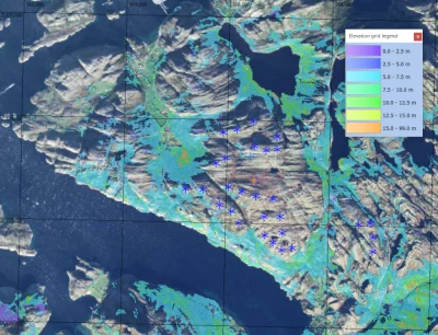
The picture shows the Norwegian SR16 Forest Map – the tree/canopy heights – at the Bessakerfjellet Wind Farm. The background image is one of the dynamic maps in windPRO – the windPRO Global Satellite Imagery in 10.0m pixel resolution.
Credit: Forest data: From the Norwegian Institute of Bioeconomy Research (NIBIO). Imagery: windPRO Global Satellite Imagery – 10m by EMD International A/S (Contains modified Copernicus Sentinel data 2016 & 2017).
Read more here:
SR16 Forest Model:
http://help.emd.dk/mediawiki/index.php?title=Norwegian_SR16_Forest_Heights
Norwegian Elevation Models:
http://help.emd.dk/mediawiki/index.php?title=Norwegian_Elevation_Models
windPRO Global Satellite Imagery:
http://help.emd.dk/mediawiki/index.php?title=WindPRO_Global_Satellite_Imagery