Swedish SLU Forest Map – Tree Heights Now Available Directly in windPRO
Forest height data for Sweden derived from the SLU Forest Map of Sweden is now available as an online data service for users of windPRO 3.2. If you are working at forested sites, you can use these forest height data as input for the dedicated forest models – that is within the displacement height calculator and the Objective Roughness Approach (ORA). Both forest models are available in windPRO 3.2. The data is available in a 25m grid resolution and is accessed from the ‘elevation grid object’ with data-type set to ‘Heights above terrain (a.g.l) for elements’.
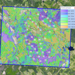
The picture above shows the SLU Forest Map – the tree heights – at a wind farm site in Sweden. The background image is one of the new dynamic maps in windPRO – the windPRO European Satellite Imagery in 2.5m resolution.
Read more here:
SLU Forest Model
windPRO European Satellite Imagery