High-resolution Italian DEM– TINITALY – now in windPRO
The Italian Elevation Model – TINITALY – is a seamless digital elevation model that covers the territory of Italy. It is produced by Tarquini et al – using a Triangular Irregular Network (TIN) approach – and built from separate elevation models from each of the administrative regions of Italy.
Grid resolution is 10m with the model beings released from the National Institute of Geophysics and Volcanology / Istituto Nazionale di Geofisica e Vulcanologia (INGV). As a part of the TINITALY dataset evaluations, the authors documented the TINITALY DEM to outperform other sources.
Click here to read more – or let us know if there is a dataset you would like to see in windPRO
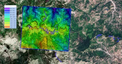
Image to the right: The TINITALY model for Italy – at work in windPRO: Wind farms just north of Randazzo, Sicily, Italy. Data-source: Tarquini S., Isola I., Favalli M., Battistini A. (2007) TINITALY, a digital elevation model of Italy with a 10 m-cell size (Version 1.0) [Data set]. Istituto Nazionale di Geofisica e Vulcanologia (INGV). https://doi.org/10.13127/TINITALY/1.0. License: CC-BY-4.0.