Full Finnish Geodata Package – Now Available in windPRO
windPRO users developing wind farms in Finland are now able to access a comprehensive package with very high-resolution Finnish national geodata. The data is easily reached through the online-data services in windPRO 3.2+. Available data includes full Finnish coverage of: The national elevation model (10m resolution), forest height data (16m resolution) and existing wind turbine positions. Finally, also topographic maps and orthophotos are available in different resolutions as dynamic zoomable maps.
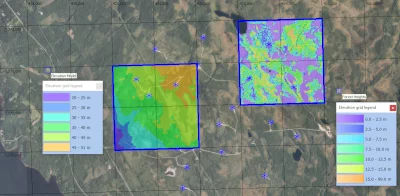
The picture shows part of the wind farm Ii / Myllykangas. It holds four of the new Finnish geo-datasets in windPRO: Finnish orthophoto as background map, the digital elevation model (10m grid), the forest height model (16m grid) and the existing turbine locations.